
Resources.
Actionable information is critical for constantly evolving surge events. This condensed list of resources can be used to understand when and how to implement flood prevention strategies.
Resources
Actionable Information.
- Find your home elevation.
- See your area in satellite images at set water elevations to understand potential impacts (NOAA Sea Level Rise Viewer).
- NOAA Extra Tropical Storm Surge uses station data to combine surge guidance, tide prediction, observed water levels, and anomalies to determine the total water guidance (maximum forecasted water elevation).
- The National Hurricane Center provides forecasts as data becomes available. The NHC forecasts worst case scenarios to save lives.
- Federal Emergency Management Administration (FEMA) provides Flood Maps to show your home’s flood zone.
- The Army Corp of Engineers are experts in building and documenting sand bag levee construction. The Army Corp of Engineers recommends sand bags are used to a maximum of 5 feet tall.
- Florida Division of Emergency Management outlines flood insurance information.
- Understand your Flood Risk at FEMA Floodsmart.gov.
- Ready.gov provides information and resources for before and after the flood.
- The National Hurricane Center also provides general information on storm surge.
Elevation Certificate
Pinellas County, Florida FEMA Elevation Certificates Map App

Find your home elevation.
- FEMA Elevation Certificate
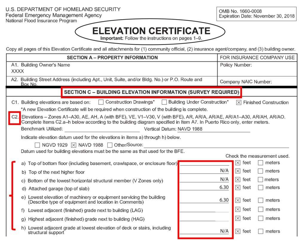
- FEMA Elevation Certificates are the easiest way to find your home’s base elevation. FEMA provides guidance on their fact sheet which notes, “Elevation Certificates (ECs) are an optional tool used by the NFIP to evaluate a building’s First Floor Height (FFH) and adjacent elevation, stay in compliance with floodplain regulations and help lower the cost of flood insurance coverage.” FEMA Elevation Certificates are required in certain areas (i.e. Flood Zone A), which is found on FEMA’s Elevation Certificate glossary.
- FEMA Elevation Certificate, Section C – Building Elevation Information (survey required) includes important elevations such as:
- Lowest elevation of machinery or equipment
- Attached garage (top of slab)
- Lowest adjacent (finished) grade next to building (LAG)
- Top of bottom floor
- Other elevations
- The home elevation on the barrier tool should reference the elevation where the things you care about are located (lowest equipment, garage, bottom floor, etc.). Ensure elevation datums are the same for all data being used for comparisons.
- I use the FEMA Elevation Certificate, Section C, C2, Part d) Attached Garage (top of slab) elevation as my home base elevation.
- Other methods to identify your home base elevation
- Google Earth or similar GIS Programs- estimate from your lawn around the house. Ensure vegetation (i.e. trees, bushes, and plants) are not causing elevations to be artificially inflated.
- U.S. Geological Survey (USGS) National Map – the search bar can be used inside the viewer to explore various layers that may include elevations.
- Hire a land surveyor to measure these elevations.
- City or County Property Appraiser – there may be links to elevation certificates in a property’s details. Each State and County will vary.
- Pinellas County, Florida FEMA Elevation Certificate website – Pinellas County, Florida’s website contains a searchable GIS map to locate elevation certificates.
Satellite Images at Set Water Elevations
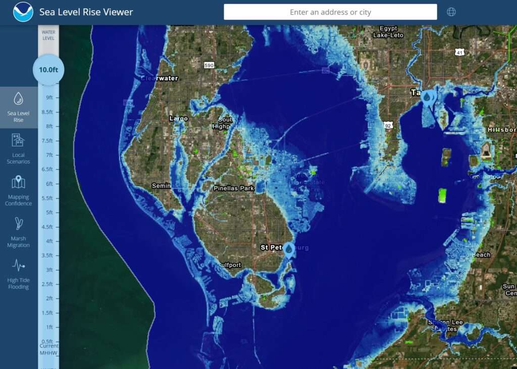
- NOAA Sea Level Rise Viewer
- Allows users to set the forecasted water level from the barrier tool to zoom into the area where their home is located. This provides users an idea of whether the streets or homes will flood based on the forecasted maximum water level for the surge event.
- Click on the link and press ‘Launch.’ Next click ‘Get Started.’ Users can either enter their address or scroll and pan to find their location. Finally set the water level bar on the left side to see the results from rising water levels.

National Hurricane Center
The National Hurricane Center (NHC) is a great place to check for forecasts. The forecast is fairly reliable several days in advance and should be regularly reviewed as a tropical system approaches to understand its path, intensity, and potential impacts.
The NHC forecasts worst case scenarios in order to save lives. If your area is placed under a tropical storm watch or warning then you should already be preparing.
Always follow federal, state, and local mandatory evacuations.
Pack to go bags containing: Passports, drivers licenses, social security cards, flood insurance policy, homeowners insurance policy, cash money, clothes for several days, toiletry items. If your house does flood you will be thankful for everything you took with you.
Case Study #1
NOAA Extratropical Data Performance
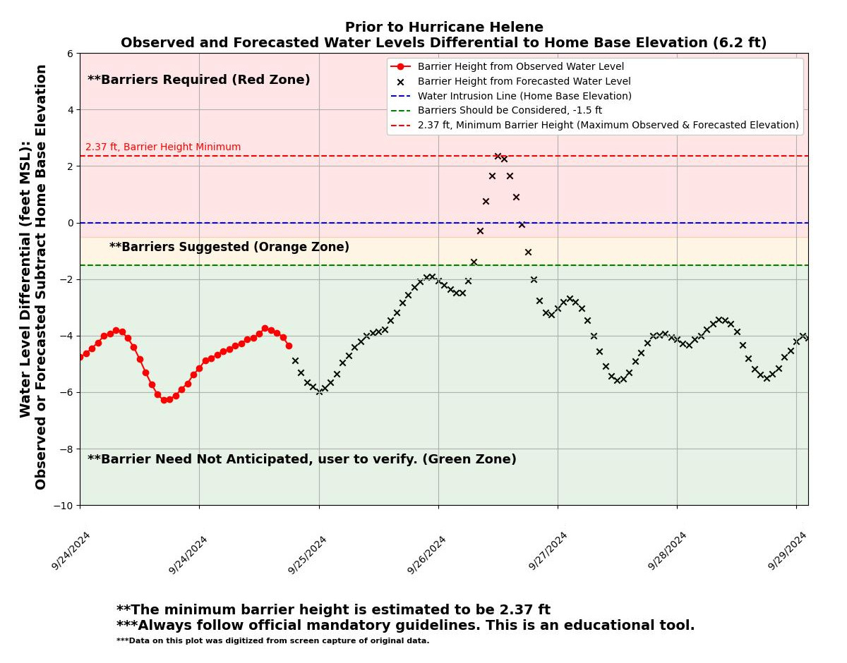
- Hurricane Helene (9/27/2024)
- The NOAA Extratropical Total Water Guidance issued on 9/25/2024 at 11:20 AM (37 hours prior) was ~8.5 feet, and the result was ~7.6 feet measured by the water line on my home.
- There was a difference of 1.3 feet (8.5 ft – 7.2 ft) between the NOAA Forecast Water Level (37 hours prior) and the Observed Water Level at the NOAA station.
- There was a difference of 0.9 feet (8.5 ft – 7.6 ft) between the NOAA Forecast Water Level (37 hours prior) and the Observed Water Level at my house.
- Hurricane Helene produced historic surge flooding not experienced in the Tampa Bay region for nearly 100 years. My neighborhood had never flooded prior, according to FEMA records and may not again for another 100 years. Hurricane Helene was a strong Category 2, strengthening into a strong Category 4 while it side swiped the Tampa Bay Area (Tampa & Saint Petersburg).
- The NOAA Extratropical Total Water Guidance issued on 9/25/2024 at 11:20 AM, which was ~37 hours prior to the storm maximum water elevation (9/27/2024 at ~1:00 AM) of approximately ~8.5 feet Mean Sea Level (MSL). This would indicate my home at a base elevation of 6.2 feet MSL would experience ~2.3 feet of surge flooding. The ~2.3 feet is the minimum forecasted size of barrier that I would need to protect my home.
- I began constructing barriers, making improvements to each barrier as each one was completed. Each barrier ranged from 2-4 feet in height depending on the limited materials I had available. The barrier construction section will note on some of the things I learned. I also had to take into consideration that I needed to evacuate from the flood zone for my own safety.
- The NOAA Extratropical Total Water Guidance issued on 9/28/2024 at 8:20 AM, noted the the Total Water Guidance Observed on 9/27/2024 at ~1:00 AM was approximately ~7.2 feet MSL. The observed water level (~7.2 feet) would indicate my home base elevation experienced 1.0 feet of water. But wait, there’s more!
- Read the entire case study here.
Prior to Hurricane Helene
Post Hurricane Helene

Prior to Hurricane Milton
Post Hurricane Milton
Case Study #2
NOAA Extratropical Data Performance
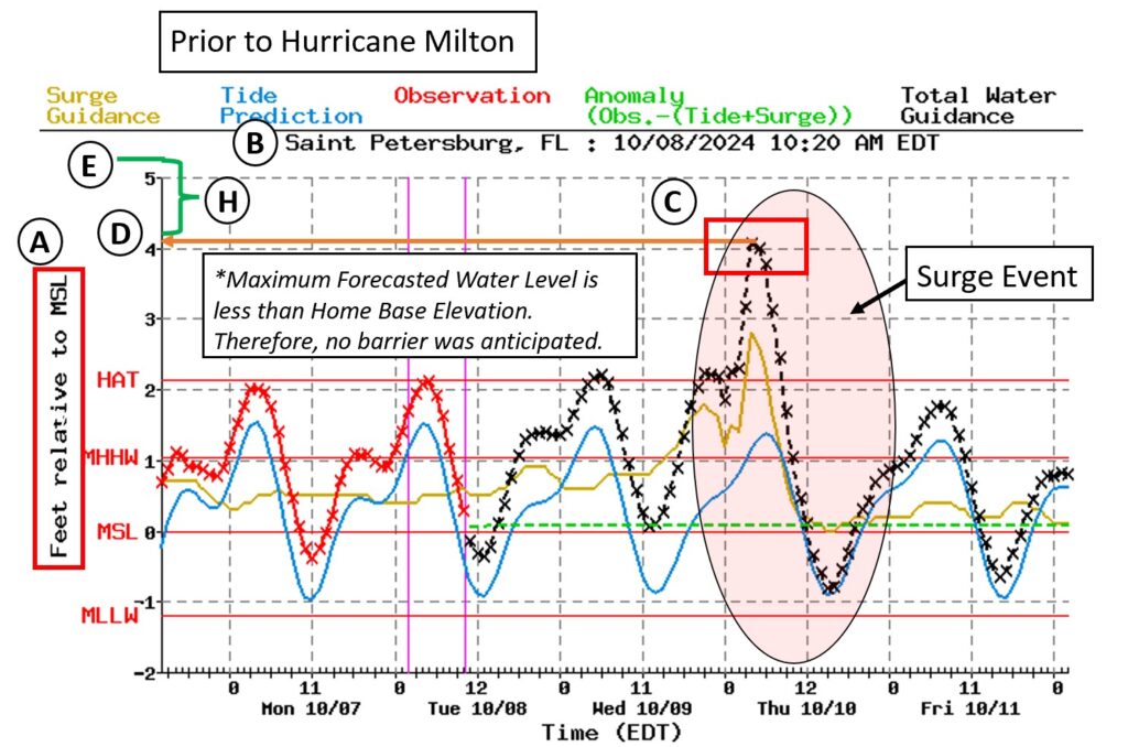
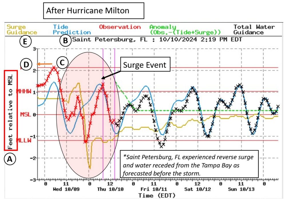
- Hurricane Milton (10/10/2024)
- Helene and Milton presented similar but different hazards. Hurricane Helene brought heavy rains, wind, and significant storm surge. Hurricane Milton brought significant winds, rainfall, and reverse storm surge where water receded out of the Tampa Bay.
- The NOAA Extratropical Total Water Guidance issued on 10/8/2024 at 10:20 AM, which was ~42 hours prior to the storm noted a maximum water elevation of approximately ~4.1 feet Mean Sea Level (MSL). The NOAA Extratropical guidance also noted there was a potential for reserve storm surge and water may recede from the Tampa Bay. The forecast indicated my home at a base elevation of 6.2 feet MSL would not experience surge flooding.
- The NOAA Extratropical Total Water Guidance issued on 10/10/2024 at 2:19 PM noted the observed surge event maximum was ~2.14 feet on 10/09/2024 at 9:00 AM. The minimum was approximately -1.28 feet MSL on 10/10/2024 at 2:00 AM, indicating that reserve storm surge had occurred.
- The forecast 42 hours prior to the maximum water elevation noted low lying areas may experience minor flooding. The track of Hurricane Milton also did slightly shift, as Milton proceeded to make landfall at Siesta Key, thus reducing the water level impacts experience in the Tampa Bay. NOAA, NHC, and local weather services provided excellent guidance throughout this storm!
- Read the entire case study here.
It is ultimately up to each person how to protect their home and how they want to proceed. Please review the disclaimer on the main page.